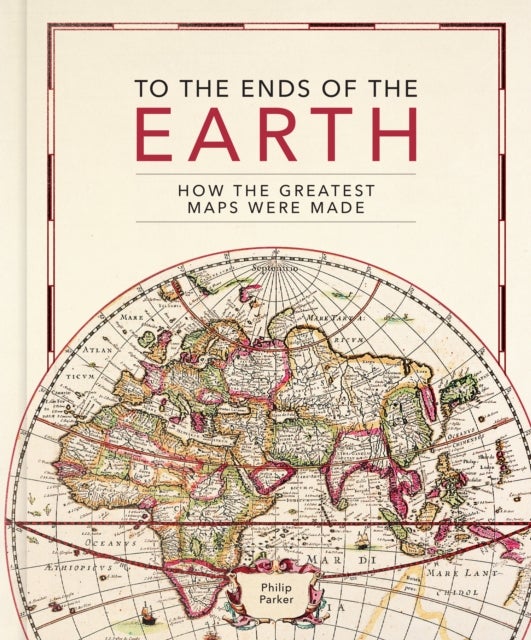
To the Ends of the Earth av Philip Parker
349,-
<B>This lavishly illustrated book provides a unique insight into the evolution of mapmaking and the science behind it, from the stone age to the digital age. </B><BR/><BR/><B>Britain’s leading cartographic author</B> takes us on a historical journey through how the greatest maps were created. Exploring <B>key cartographers</B> and mapmaking methods, as well as fascinating interludes on subjects such as the very first maps, deliberate mistakes, and superlative maps, this comprehensive guide explores how the <B>techniques and technology have developed</B> throughout human history:<BR/><BR/>• <B>Evolving methods of surveying</B>: from the Roman groma, through the naval instruments of the magnetic compass, astrolabes and sextants, to the 20th century revolution of aerial photography <BR/>• <B>Drawing tools and materials</B>: from Babylonian maps carved in clay, to digital maps created via touchscreen<BR/>• The introduction of <B>various mapping conventi

Relaterte produkter
Vis flereVi har valgt ut en rekke interessante produkter i samme kategori som To the Ends of the Earth av Philip Parker. Hvis du ikke finner noe interessant her kan du enkelt klikke på “vis flere”.


Produktinformasjon
- Alle prisene nevnt ovenfor er oppgitt i Norske kroner.
- Dette produktet er tilgjengelig hos Norli NO.
- Hos Norli NO kan du kjøpe To the Ends of the Earth av Philip Parker for kun 349,-.
- Den laveste prisen på To the Ends of the Earth av Philip Parker ble registrert 17. februar 2025 kl. 14:48.
Prisutvikling
Er den nåværende prisen et godt tilbud?
Grafen over prisutviklingen viser den laveste prisen over tid, eksklusiv fraktkostnader.
Prishistorikk for To the Ends of the Earth av Philip Parker
Laveste pris
349,-
17 feb. 2025
Høyeste pris
349,-
17 feb. 2025