Road Atlas Ireland av Collins Maps
129,-
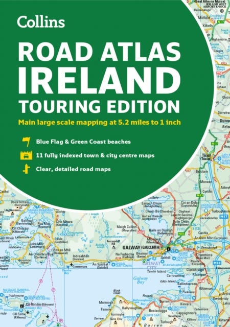
Explore Ireland with this accurate and fully updated road atlas.This road atlas is at A4 size, covering the whole of Ireland and features clear and detailed Collins colour mapping at a scale of 5.2 miles to 1 inch. Perfect for both residents and visitorstouring Ireland.This revised edition includes:Places of tourist interestContact information for Tourist Information Centres with grid references to the mappingFully indexed street maps of 11 cities and towns ¿ Dublin, Belfast, Cork, Limerick, Waterford,Londonderry (Derry), Galway, Bangor, Dun Laoghaire, Drogheda and KillarneyBlue Flag & Green Coast beachesFerry and airport information; Distance chart; Distances marked on the roads in miles and kilometresRoute planning map of the whole of Ireland at 15.8 miles to 1 inchAdministrative map of Irish counties and districts.

Relaterte produkter
Vis flereVi har valgt ut en rekke interessante produkter i samme kategori som Road Atlas Ireland av Collins Maps. Hvis du ikke finner noe interessant her kan du enkelt klikke på “vis flere”.


Righteous av Joe Ide
169,-


Produktinformasjon
- Alle prisene nevnt ovenfor er oppgitt i Norske kroner.
- Dette produktet er tilgjengelig hos Norli NO.
- Hos Norli NO kan du kjøpe Road Atlas Ireland av Collins Maps for kun 129,-.
- Den laveste prisen på Road Atlas Ireland av Collins Maps ble registrert 17. februar 2025 kl. 14:48.
Prisutvikling
Er den nåværende prisen et godt tilbud?
Grafen over prisutviklingen viser den laveste prisen over tid, eksklusiv fraktkostnader.
Prishistorikk for Road Atlas Ireland av Collins Maps
Laveste pris
129,-
17 feb. 2025
Høyeste pris
129,-
17 feb. 2025